World Fisheries Day falls on 21 November, the date in 1997 when fishworkers from 18 countries met in New Delhi and founded the World Fisheries Forum. On 30 October 2026, PIB reported that India's fisheries are moving "beyond production" to processing, cold chains and mobile fish markets. The Centre has committed ₹39,272 crore to the sector since 2015, aimed at creating jobs and livelihoods for 74.66 lakh fishers and fish farmers. Yet fish are found in only a few parts of the sea. Every great fishing ground lies where a warm current, a cold current, a shallow shelf or rising deep water comes together. So UPSC's questions on currents, El Niño and the EEZ are really questions about fishing grounds.
Why Fish Crowd Into a Few Patches of Sea
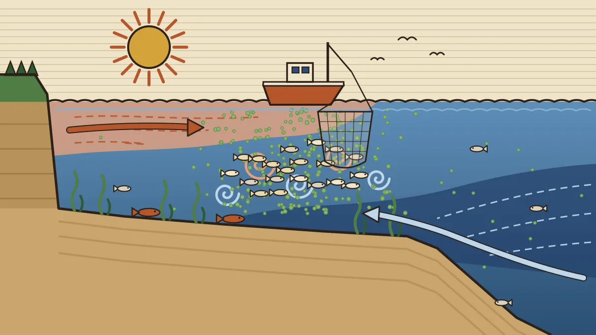
Every food chain in the sea starts with phytoplankton, microscopic drifting plants. Zooplankton eat them, small fish such as sardine and herring eat the zooplankton, and cod, tuna, seabirds and people eat the small fish. Phytoplankton need sunlight, which reaches only the top 200 metres or so, and nutrients such as nitrates and phosphates. Dead matter sinks, so the nutrients collect in the dark deep water. A sea is rich only where something lifts that water back into the light.
| Condition | Why it helps | Example |
|---|---|---|
| Continental shelf | Shallow, so light reaches deep and tides stir the bottom; rivers add nutrients; bottom fish feed and spawn on the floor | North Sea |
| Warm meets cold current | Cold water is rich in nutrients and oxygen; the meeting churns it into the light | Grand Banks, north-east Japan |
| Upwelling | Offshore winds push surface water away and cold deep water rises | Peru, Namibia |
| Cool temperate water | Winter cooling overturns the water; huge shoals of a few species are easy to net | North Atlantic, North Pacific |
NCERT puts the average width of the continental shelf at about 80 km. The Siberian shelf is the widest, at up to about 1,500 km, and shelves are almost absent off Chile. Fishermen sort fish by habitat. Pelagic fish (herring, sardine, anchovy, mackerel, tuna) swim in open water. Demersal fish (cod, haddock, hake, plaice, sole) live near the bottom and are trawled, which is why shallow shelves matter so much. Biologists say plankton drift, nekton swim freely and benthos live on the floor.
Fish need light + nutrients + stirring. Shelves give light, cold water gives nutrients, and meeting currents or upwelling do the stirring.
Where Warm Meets Cold: Grand Banks, North Sea and Japan
Our ocean currents page lists which currents are warm and which cold. Where they meet, the cold current supplies nutrients and oxygen, and the warm one keeps the sea ice-free. Eddies along the front between them lift the nutrients into sunlit water, plankton bloom, and fish follow.
Grand Banks, off Newfoundland (Canada). These shallow submarine plateaus, mostly under 100 metres deep, are where the cold Labrador Current meets the warm Gulf Stream. They became the world's most famous cod ground. Moist air from over the Gulf Stream is chilled crossing the cold water, producing thick advection fog, most frequent in summer. The Labrador Current also carries icebergs south; one sank the Titanic south of the banks in 1912. Industrial trawling wrecked the stock. On 2 July 1992 Canada banned cod fishing, when spawning northern cod had fallen to about 1 per cent of its peak. Nearly 30,000 people in Newfoundland and Labrador lost their jobs.
North Sea and Dogger Bank. The North Sea is a shallow shelf sea, stirred by strong tides and fed by water from the warm North Atlantic Drift. The Dogger Bank, a vast sandbank between England and Denmark, is in places less than 20 metres deep. It was long a prime ground for herring, cod and plaice. Farther north, warm Atlantic water meets cold Arctic water off Norway and Iceland, which land cod, herring and capelin. Iceland fought three "Cod Wars" with Britain between 1958 and 1976 as it pushed its fishing limit out to 200 nautical miles.
North-west Pacific. The warm Kuroshio flows north past Japan and meets the cold Oyashio, coming south from the Kuril Islands, off north-east Honshu. Kuroshio means "black current", after its deep-blue water, so clear because it carries few nutrients. Oyashio means "parent current", because it nourishes the fish. The mixing zone yields sardine, saury, mackerel, squid and salmon. FAO has long ranked the north-west Pacific the most productive fishing area in the world.
Upwelling: Peru, Benguela and the El Niño Crash
On the western coasts of continents in the trade-wind belt, winds blow along the shore towards the equator. The Earth's rotation turns the surface water they drive offshore, and cold water from below rises to replace it. There are four great upwelling systems: California, Humboldt (Peru–Chile), Canary and Benguela. Together they cover roughly 1 per cent of the ocean, yet they have produced up to about a fifth of the world's marine catch.
Off Peru, the south-east trades blow northward along the coast. Why does the surface water move away from land?
Peru. The cold Humboldt (Peru) Current and its upwelling support the Peruvian anchoveta, in most years the largest catch of any single fish species. Most of it becomes fishmeal and fish oil for farmed fish, pigs and poultry worldwide. Peru's shelf is narrow; its riches come from upwelling.
El Niño. Every few years the trade winds weaken and warm water from the western Pacific spreads east. Peruvian fishermen named the warming El Niño, "the Christ child", because it tends to arrive around Christmas. A warm, nutrient-poor layer caps the coast, so upwelling brings up warm water instead of cold. Plankton crash, the anchoveta scatter or die, and the guano birds starve. Peru's catch hit a record of about 12 million tonnes in 1970. During the 1972–73 El Niño, with heavy overfishing on top, it fell to 1.8 million tonnes by 1973. The same event often weakens India's monsoon, as our explainer on El Niño and the monsoon shows.
The Humboldt is cold; El Niño is warm. Peru is rich despite a narrow shelf. The Benguela flows north along south-west Africa (Namibia); north-west Africa is the Canary Current's coast.
The Grounds at a Glance, and Why the Tropics Lag
| Fishing ground | What makes it rich | Key catch |
|---|---|---|
| Grand Banks | Labrador (cold) meets Gulf Stream (warm) over shallow banks | Cod, haddock |
| North Sea, Dogger Bank | Shallow, tide-stirred shelf; North Atlantic Drift water | Herring, cod, plaice |
| Norway–Iceland | Atlantic water meets Arctic water | Cod, herring, capelin |
| North-west Pacific | Kuroshio (warm) meets Oyashio (cold) | Sardine, saury, squid |
| Peru–Chile | Humboldt upwelling | Anchoveta |
| Namibia–South Africa | Benguela upwelling | Pilchard, hake |
| Morocco to Senegal | Canary upwelling | Sardine |
Why do sunny tropical seas catch less?
- Locked nutrients. A warm, light surface layer floats on cold, dense water below a permanent thermocline, and there is no winter overturning. The open tropical ocean is deep blue precisely because it holds little plankton.
- Many species, few of each. Coral reefs and mangroves are rich in variety, but one species rarely forms a shoal big enough to net, and reefs cannot be trawled.
- Narrow shelves and spoilage. Many tropical shelves are narrow, and catch rots fast in the heat.
Exceptions exist. Tuna roam the open tropical ocean, and the Indian Ocean tuna fishery shapes diplomacy, as in our article on India and Seychelles talking tuna. The Arabian Sea is productive because the summer monsoon drives upwelling off Somalia, Oman and south-west India.
India: Seas, Rivers and Ponds
| Indicator | Figure |
|---|---|
| World rank | 2nd in fish (after China), about 8% of world output; 2nd in aquaculture |
| Production | About 197.75 lakh tonnes in 2024-25 (provisional), double the 95.79 lakh tonnes of 2013-14 |
| Inland vs marine | Inland about 77%, marine about 23% |
| Top state | Andhra Pradesh (about 28%), mostly pond shrimp and carp |
| Marine landings 2024 (CMFRI) | 3.47 million tonnes; Gujarat first, then Tamil Nadu, Kerala; top fish Indian mackerel, then oil sardine |
| EEZ, coastline | EEZ about 2.02 million sq km (the long-standing official figure); coastline re-measured at 11,098.81 km (earlier 7,516.6 km) |
| Seafood exports | Record ₹62,408 crore in 2024-25, led by frozen shrimp |
India's fish now come mostly from inland waters, above all ponds stocked with the Indian major carps (catla, rohu, mrigal) and shrimp. At sea, about three-fifths of landings come from the west coast. The Arabian Sea shelf is wider, especially off Gujarat and Maharashtra, and monsoon upwelling off Kerala and Karnataka feeds the oil sardine and mackerel. The Bay of Bengal, freshened by great rivers, is strongly layered and less productive.
A uniform 61-day ban on mechanised and motorised fishing in the EEZ runs from 15 April to 14 June on the east coast and 1 June to 31 July on the west coast. Traditional non-motorised craft are exempt, and coastal states impose matching bans within 12 nautical miles. It protects breeding fish and keeps boats off rough seas. In CMFRI's 2024 data, April–June was the leanest quarter (17.7% of landings).
Schemes. The Blue Revolution scheme was approved in December 2015 with ₹3,000 crore for five years; keep it apart from the Green and White revolutions on our agriculture page. The Pradhan Mantri Matsya Sampada Yojana (PMMSY) was launched on 10 September 2020 with ₹20,050 crore over five years. PM-MKSSY, a PMMSY sub-scheme approved in February 2024 (about ₹6,000 crore), aims to formalise small fishers and widen their access to credit. The October 2026 PIB release counts 2,195 Fisheries Farmer Producer Organisations. Overfishing is the other half of the story, and India's acceptance of the WTO agreement on fisheries subsidies addresses it.
How UPSC Has Asked It: Past Papers Solved
UPSC rarely writes "fishing ground"; it asks about the currents, El Niño and sea law behind one.
Which one of the following is not a resultant of the El Nino effect?
(a) Distortion of equatorial atmospheric circulation (b) Flow of the South-East Trade Winds towards the Indian Ocean (c) Irregularities in the evaporation of sea water (d) Reduction in the amount of planktons which reduces the number of fish in the sea
Answer: (b). Trades blowing west across the Pacific are the normal state; El Niño weakens them. Option (d) may look odd, but the plankton crash off Peru is El Niño's best-known effect.
Which one of the following ocean currents is NOT a cold ocean current?
(a) Canary current (b) California current (c) Kuroshio current (d) Oyashio current
Answer: (c). The Kuroshio is warm. The Oyashio is the trap: both names end in "-shio" (Japanese for current), but they are opposites, and their meeting enriches the north-west Pacific.
Which one of the following is not a cold current?
(a) Western Australian Current (b) Eastern Australian Current (c) Benguela Current (d) Peru Current
Answer: (b). The East Australian Current carries warm water south along an eastern coast. The other three flow up western coasts towards the equator; the Benguela and Peru currents drive two of the great upwelling fisheries.
Consider the following oceanic currents: I. Oyashio II. Canaries III. Labrador IV. Kuroshio V. Benguela VI. Alaska VII. Humboldt. How many of the above are Pacific Ocean currents?
(a) One (b) Two (c) Three (d) Four
Answer: (d). Oyashio, Kuroshio, Alaska and Humboldt are Pacific; Canaries, Labrador and Benguela are Atlantic. Anyone who places the Labrador off Alaska counts five, but it flows past eastern Canada to the Grand Banks.
Which one of the following is not an exclusive right of the concerned coastal nations over Exclusive Economic Zone (EEZ)?
(a) Survey and exploitation of mineral resources of ocean deposits (b) Exploitation of marine water energy and marine organisms including fishing (c) Conservation and management of marine resources (d) Navigation of ships and laying down submarine cables
Answer: (d). Under UNCLOS, all states may sail through an EEZ and lay cables in it. Fishing (b) is the core exclusive right, which is why Iceland's Cod Wars were fought over where the limit lay.
Expect a warm-or-cold current question almost every year and an El Niño question every few papers. Learn currents in pairs that meet (Gulf Stream–Labrador, Kuroshio–Oyashio) and the four west-coast upwelling currents (California, Humboldt, Canary, Benguela).
Practice MCQs (with answers)
- The Grand Banks fishing ground lies where
- the Gulf Stream meets the Labrador Current
- the Kuroshio meets the Oyashio
- the North Atlantic Drift meets the Canary Current
- the Brazil Current meets the Falkland Current
- Peru has a narrow continental shelf yet one of the world's largest fisheries, mainly because of
- the warm El Niño current
- extensive coral reefs
- upwelling of cold, nutrient-rich water
- silt from the Amazon
- Which of these is a demersal fish, usually trawled near the sea floor?
- Sardine
- Anchoveta
- Tuna
- Cod
- India's uniform 61-day fishing ban off the west coast runs from
- 15 April to 14 June
- 1 June to 31 July
- 1 July to 31 August
- 15 May to 14 July
- Consider: 1. Inland fisheries produce about three-quarters of India's fish. 2. India is the world's second-largest fish producer. 3. Kerala is India's largest fish-producing state. Which are correct?
- 1 only
- 1 and 2 only
- 2 and 3 only
- 1, 2 and 3
- Clear, deep-blue water in the open tropical ocean usually indicates
- little plankton, as a permanent thermocline traps nutrients below
- a dense plankton bloom
- strong upwelling
- heavy river inflow
- The Dogger Bank is in the
- Gulf of Mexico
- Sea of Japan
- Bering Sea
- North Sea
- During a strong El Niño, off the coast of Peru
- trade winds strengthen and upwelling increases
- cold Humboldt water spreads farther north
- warm, nutrient-poor water caps the coast and the anchoveta catch falls
- sea-surface temperature falls sharply
1-a, 2-c, 3-d, 4-b, 5-b, 6-a, 7-d, 8-c. Q4: 15 April–14 June is the east coast ban. Q5: Andhra Pradesh, not Kerala, leads, through pond aquaculture. Q8: El Niño weakens the trades, so (a), (b) and (d) describe the opposite, La Niña-like state.
Quick Revision
- Fish need light (top ~200 m), nutrients (from cold, deep water) and stirring: shelves, warm–cold meeting zones, upwelling coasts.
- Grand Banks: Labrador + Gulf Stream; cod; advection fog; cod ban 2 July 1992. North Sea/Dogger Bank: shallow, tide-stirred; herring, cod.
- North-west Pacific: Kuroshio (warm, "black") + Oyashio (cold, "parent"); FAO's most productive area.
- Upwelling: California, Humboldt, Canary, Benguela (~1% of ocean, up to a fifth of catch). Peru anchoveta → fishmeal. El Niño: no cold upwelling, catch crash (12 Mt in 1970 → 1.8 Mt in 1973).
- Tropics lag: permanent thermocline, mixed species, narrow shelves. Exception: Arabian Sea monsoon upwelling.
- India: 2nd in fish (~8%) and aquaculture; ~197.75 lakh t (2024-25); inland ~77%; Andhra Pradesh top; Gujarat tops marine; mackerel > oil sardine; EEZ ~2.02 million sq km.
- Ban: east 15 Apr–14 Jun, west 1 Jun–31 Jul. Blue Revolution Dec 2015; PMMSY 10 Sep 2020 (₹20,050 cr); PM-MKSSY Feb 2024.
Frequently asked questions
Why are the Grand Banks such a rich fishing ground?
The Grand Banks off Newfoundland are shallow, mostly under 100 metres, so sunlight reaches far down. There the cold, nutrient-rich Labrador Current meets the warm Gulf Stream, and the mixing lifts nutrients into sunlit water where plankton bloom and fish gather. The same meeting causes the area's famous fog.
Why does El Niño hurt Peru's fishery?
Peru's anchoveta depend on cold, nutrient-rich water welling up along the coast. During El Niño the trade winds weaken and warm, nutrient-poor water spreads over the coast, so upwelling brings up warm water instead. Plankton decline and the catch collapses, as it did in 1972–73.
Why do tropical seas produce fewer fish?
A warm surface layer sits permanently on top of cold deep water, so nutrients stay trapped below the sunlit zone and plankton are scarce. Tropical waters also hold many species but few large shoals of any one, and many tropical shelves are narrow.
What is India's rank in world fish production?
India is the world's second-largest fish producer after China, with about 8 per cent of global output, and is second in aquaculture. Production was about 197.75 lakh tonnes in 2024-25 (provisional), roughly three-quarters of it from inland waters. Andhra Pradesh is the leading state.
When is the fishing ban imposed in Indian waters?
A uniform 61-day ban on mechanised and motorised fishing applies in the EEZ every year: 15 April to 14 June on the east coast and 1 June to 31 July on the west coast. It protects fish in the breeding season and keeps boats off rough monsoon seas. Traditional non-motorised craft are exempt.
Related CDS / OTA Geography topics
Physical geography is the most predictable block of the CDS GS paper
Cavalier's CDS/OTA batches teach currents, climate and resources with diagrams, maps and weekly PYQ-based tests.