On 28 October 2026, Cyclone Arnab crossed the Andhra Pradesh–Yanam coast. Meanwhile, the north-east monsoon was settling over Tamil Nadu, the one part of India that gets more rain from October to December than in the "rainy season" itself. Both happen because the monsoon is a system, not a season. It is a seasonal reversal of winds driven by the sun, the land, the oceans and winds blowing eight to fifteen kilometres up. Understanding how it works answers most monsoon questions, whether they ask why Rajasthan stays dry, why Mawsynram floods, or which crop the western disturbances help.
What the Monsoon Is, and What It Is Worth
"Monsoon" comes from the Arabic mausim, meaning season. Arab sailors used the word for the winds that blow from the south-west in summer and from the north-east in winter. The defining feature is a seasonal reversal of wind direction, which is why NDA 2023-II asked which climate type is marked by it (answer: the monsoon climate).
The India Meteorological Department (IMD) divides the year into four seasons:
| Season (IMD) | Months | What happens |
|---|---|---|
| Winter | January–February | Cold, dry north-easterly winds; western disturbances bring rain and snow to the north-west |
| Pre-monsoon (hot weather) | March–May | Heating of the land; local storms such as Nor'westers, mango showers, the Loo |
| South-west monsoon | June–September | About 75% of India's annual rainfall |
| Post-monsoon (retreating) | October–December | Monsoon withdraws; cyclones in the Bay of Bengal; north-east monsoon over Tamil Nadu |
The benchmark is the Long Period Average (LPA) of the June–September rainfall for the whole country. It is 87 cm, based on 1971–2020. IMD calls a season normal when rainfall is 96–104% of the LPA, deficient below 90% and excess above 110%. Roughly half of India's net sown area depends on rain, so these percentages decide the kharif harvest, rural incomes and food inflation.
Five Forces That Drive the South-West Monsoon
Textbooks once explained the monsoon as a giant sea breeze. That theory goes back to Edmund Halley in 1686: land heats faster than sea, so air rises over hot land and moist sea air flows in. That is still the starting point, but it cannot explain the timing, the sudden onset or the failures. The modern explanation adds four more forces.
- Differential heating. By May, an intense low-pressure area forms over north-west India and Pakistan. A high-pressure area, the Mascarene High, sits over the southern Indian Ocean near Madagascar. Air flows from the high to the low.
- The ITCZ moves north. The Inter-Tropical Convergence Zone, the belt where the trade winds of the two hemispheres meet, shifts north with the overhead sun. In July it lies at about 20–25°N over the Ganga plain, where it is called the monsoon trough. The south-east trades of the southern hemisphere cross the equator, and the Coriolis force bends them to the right, so they reach India as the south-west monsoon.
- The Tibetan Plateau. In summer the plateau acts as a raised hot plate. The heated air rises and builds an upper-level high. That high helps form the Tropical Easterly Jet, which blows from east to west high over peninsular India in summer and strengthens the monsoon circulation.
- The westerly jet jumps north. In winter the subtropical westerly jet flows south of the Himalayas. In early June it shifts north of the Tibetan Plateau. Its departure removes a lid on the atmosphere, and the monsoon arrives with a sudden "burst" of heavy rain.
- Ocean signals far away.
- An El Niño (warm waters in the eastern Pacific) usually weakens the Indian monsoon, and a La Niña usually strengthens it.
- A positive Indian Ocean Dipole (warmer western Indian Ocean) tends to help.
- The Madden–Julian Oscillation, a pulse of clouds moving east along the equator, causes the active and weak spells within a season.
- Near the surface, the Somali (Findlater) jet, a fast low-level stream off the coast of East Africa, carries moisture across the Arabian Sea.
Jet streams and local winds are explained step by step on our page on winds, jet streams and local wind systems. The ocean side is covered in our explainer on El Niño, the IOD and the monsoon.
Onset, Burst, Break and Withdrawal
IMD revised its "normal dates" in 2020, using data from 1961–2019 for onset and 1971–2019 for withdrawal. These are the figures to quote:
| Milestone | Normal date | Note |
|---|---|---|
| Onset over Kerala | 1 June (± 7 days) | Declared using rainfall, wind and cloud criteria |
| Covers the entire country | 8 July | Was 15 July before 2020 |
| Withdrawal begins (north-west India) | 17 September | Was 1 September before 2020 |
| Withdrawal complete | 15 October | The north-east monsoon takes over in the south |
Break in the monsoon. In some weeks of July and August, the monsoon trough shifts north to the foothills of the Himalayas. Rain then stops over the plains for a week or more, while the hills and the Brahmaputra valley flood. A long break during sowing is what turns a "normal" monsoon into a bad year for farmers.
Cloudburst. IMD defines a cloudburst as about 10 cm of rain in an hour over a small area of roughly 20–30 sq km. Cloudbursts are most common in the Himalaya during the monsoon, and they trigger flash floods and landslides (NDA 2022-I, below).
Two Branches, and Why the Rain Is So Uneven
The peninsula's shape splits the monsoon in two.
The Arabian Sea branch
- Western Ghats: the winds strike the Ghats almost at right angles. They rise, cool and pour more than 250 cm of rain on the windward slopes. Crossing the crest, the air descends and warms, leaving a rain-shadow on the Deccan plateau. That is why Pune and the interior of Karnataka are far drier than the coast only 100 km away.
- Narmada–Tapi trough: a second stream enters through this corridor into central India.
- Gujarat and Rajasthan: a third stream runs through Saurashtra and Kutch into Rajasthan. The Aravallis lie parallel to its path, so nothing forces the air to rise. Western Rajasthan stays the driest part of the plains.
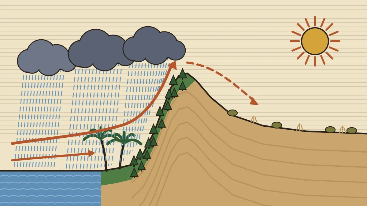
The Bay of Bengal branch
- It strikes the coast of Myanmar and the Arakan Yoma, then turns into north-east India.
- In Meghalaya, the funnel-shaped valleys of the Garo and Khasi hills trap it. Mawsynram and Cherrapunji (Sohra) receive the heaviest rainfall in the world.
- The Himalaya then deflects it westward along the Ganga plain, and it grows drier as it goes, from Kolkata to Patna to Allahabad to Delhi.
- The two branches merge over the north-western Ganga plain.
Two reasons. The Coromandel coast lies in the rain-shadow of the Western Ghats for the Arabian Sea branch, and the Bay of Bengal branch blows parallel to the Tamil Nadu coast instead of onto it. Its rain comes later, from the north-east monsoon.
Overall, rainfall exceeds 200 cm on the west coast and in the north-east. It falls below 50 cm in western Rajasthan, parts of Gujarat, the interior Deccan and Ladakh. The Köppen codes that capture this pattern, such as Amw on the west coast south of Goa, BWhw in the extreme west of Rajasthan, and As on the Coromandel coast (the 's' marks a dry summer, which is the north-east monsoon pattern), are explained on our Köppen classification page.
The Retreat and the North-East Monsoon
From mid-September the land cools, the low over north-west India weakens, and the monsoon trough slides south. The withdrawing monsoon leaves clear skies with high temperature and humidity behind it. This muggy spell is called "October heat". By early November the low-pressure area has moved over the Bay of Bengal. That is why October and November are the peak months for tropical cyclones that hit the east coast, as Cyclone Arnab did at Yanam this October. Our explainer on how Bay of Bengal storms are named and ranked covers the cyclone side.
The winds now blow from the north-east. Over most of India they come from the land, so they are dry. Before reaching the south-east coast, however, they cross the Bay of Bengal and pick up moisture. This north-east monsoon (October–December) waters:
- Tamil Nadu and Puducherry;
- coastal Andhra Pradesh and Rayalaseema;
- south interior Karnataka and Kerala.
According to IMD's climatology for 1971–2020, Tamil Nadu and Puducherry receive about 44 cm, or 48% of their annual rainfall, in October–December. They get only about 35% from the south-west monsoon. October and November share most of it, about 17 cm and 18 cm, and by December the rain is confined to the coastal districts. This is why Chennai's floods come in November and December, not in July.
The CDS asked exactly this in 2018: South Arcot and Ramanathapuram, two Coromandel districts, get more than half their rain from the north-east monsoon.
Western Disturbances and Pre-Monsoon Storms
Two smaller rain-makers fill the gaps.
Western disturbances
- These are low-pressure systems that originate over the Mediterranean Sea and western Asia. They are not born over the Caspian, a trap in NDA 2026-II.
- The westerly jet steers them into India in winter.
- They bring snow to Jammu and Kashmir, Ladakh and Himachal, and light rain to Punjab, Haryana and western Uttar Pradesh.
- That winter rain is very valuable for the rabi crop, above all wheat (NDA 2023-II).
Pre-monsoon storms (March–May)
- Nor'westers / Kalbaisakhi: violent evening thunderstorms in West Bengal, Odisha and Assam (where they are called Bardoli chheerha). They help the jute, rice and tea crops.
- Mango showers: pre-monsoon showers in Kerala and coastal Karnataka that help mangoes ripen.
- Blossom showers: rain that makes coffee flowers bloom in Kerala and the nearby hills.
- Loo: hot, dry, dusty westerly winds that blow in the afternoons over the northern plains in May and June.
The monsoon also leaves a record behind. Our article on a dead meander near Lucknow that stores 4,600 years of monsoon history shows how scientists read past rainfall in lake sediments.
How UPSC Has Asked It: Past Papers Solved
These are actual CDS and NDA questions since 2018. The monsoon is asked through places (which district, which state) and through mechanisms (which wind, which crop).
South Arcot and Ramanathapuram receive over 50 percent of their annual rainfall from which one of the following?
(a) South-west monsoon (b) North-east monsoon (c) Bay of Bengal branch of summer monsoon (d) Western disturbances
Answer: (b). Both districts lie on the Coromandel coast, in the rain-shadow of the Western Ghats in summer and parallel to the Bay of Bengal branch. Their main rain arrives in October–December, from north-east winds that pick up moisture over the Bay.
Which one of the following crops is generally benefitted by the rain caused by western disturbances in India?
(a) Rice (b) Wheat (c) Bajra (d) Cotton
Answer: (b). Western disturbances rain in winter, during the growth of the rabi crop. Rice, bajra and cotton are kharif crops that depend on the south-west monsoon.
Consider the following statements regarding western disturbances in the Indian climate: I. These are shallow cyclonic depressions. II. They originate over the Caspian Sea and travel to India.
(a) I only (b) II only (c) Both I and II (d) Neither I nor II
Answer: (a). They are low-pressure (cyclonic) systems, but they originate over the Mediterranean and western Asia and are carried in by the westerly jet. Swapping one sea for another is a standard UPSC trick.
Which one of the following climatic regions of the world have a typical characteristic of seasonal reversal of wind?
(a) British type Climate (b) Mediterranean Climate (c) China type Climate (d) Monsoon Climate
Answer: (d). The reversal of wind with the seasons, onshore in summer and offshore in winter, is the very definition of the monsoon climate. The British and Mediterranean types are governed by westerlies instead.
According to the Indian Meteorological Department, which of the following is/are the feature/features of cloudburst? 1. Heavy precipitation in short period of time in a limited geographical area. 2. It occurs generally during monsoon period and triggers flash flood and landslides.
(a) 1 only (b) 2 only (c) Both 1 and 2 (d) Neither 1 nor 2
Answer: (c). IMD's working definition is about 10 cm in an hour over roughly 20–30 sq km. Cloudbursts are a monsoon-season hazard of the hills, so both statements are correct.
Expect one monsoon question per paper. It is usually a "which region or crop" question (north-east monsoon, western disturbances, rain-shadow) or a definition (reversal of winds, cloudburst, burst). Revise the branch map and the four IMD seasons, and most of these become one-glance answers.
Practice MCQs (with answers)
- The Long Period Average of India's south-west monsoon rainfall, based on 1971–2020, is about
- 78 cm
- 87 cm
- 98 cm
- 116 cm
- The sudden onset of heavy rain at the start of the monsoon is linked to
- the westerly jet moving south of the Himalayas
- the arrival of western disturbances
- the subtropical westerly jet shifting north of the Tibetan Plateau
- a La Niña in the Atlantic
- Western Rajasthan receives little rain from the Arabian Sea branch mainly because
- the Aravallis lie parallel to the wind direction
- it lies in the rain-shadow of the Western Ghats
- the Bay of Bengal branch blocks it
- the Loo blows all through the monsoon
- Which of the following is the normal date by which the monsoon covers the entire country, as revised by IMD in 2020?
- 1 July
- 15 July
- 30 June
- 8 July
- "October heat" refers to
- the hot dry Loo of the Ganga plain
- high temperature and humidity after the monsoon withdraws
- heat waves caused by El Niño
- temperatures before the onset over Kerala
- Nor'westers are most closely associated with which crops?
- Wheat and barley
- Cotton and groundnut
- Jute, rice and tea
- Coffee and pepper
- Which factor generally weakens the Indian south-west monsoon?
- An El Niño in the eastern Pacific
- A positive Indian Ocean Dipole
- A strong Tropical Easterly Jet
- A deep low over north-west India
- The world's heaviest rainfall at Mawsynram is caused mainly by
- the Arabian Sea branch striking the Western Ghats
- western disturbances
- the north-east monsoon
- the Bay of Bengal branch trapped by the Garo and Khasi hills
1-b, 2-c, 3-a, 4-d, 5-b, 6-c, 7-a, 8-d. Q4: the pre-2020 normal of 15 July is the trap. Q7: a positive IOD, a strong easterly jet and a deep north-west low all help the monsoon.
Quick Revision
- Monsoon = seasonal reversal of winds (Arabic mausim). The south-west monsoon (June–September) gives ~75% of India's rain; LPA 87 cm (1971–2020); normal = 96–104%.
- Drivers: land–sea heating; northward ITCZ (monsoon trough); Tibetan heating and the Tropical Easterly Jet; the westerly jet moving north of Tibet (burst); Somali jet; ENSO, IOD and MJO.
- Normal dates: Kerala 1 June; whole country 8 July; withdrawal starts 17 September; complete 15 October.
- Arabian Sea branch: Western Ghats (heavy rain, Deccan rain-shadow); Aravallis parallel, so Rajasthan stays dry. Bay of Bengal branch: Meghalaya (Mawsynram), then west along the Ganga plain, drying as it goes.
- Retreat: "October heat", Bay cyclones in October–November. North-east monsoon (October–December): Tamil Nadu gets 48% of its annual rain (IMD, 1971–2020).
- Western disturbances: Mediterranean origin, westerly jet, winter rain, good for wheat. Pre-monsoon: Nor'westers (jute, tea), mango showers (Kerala, coastal Karnataka), blossom showers (coffee), Loo.
Frequently asked questions
Why does Tamil Nadu get most of its rain in winter?
During the south-west monsoon, Tamil Nadu lies in the rain-shadow of the Western Ghats, and the Bay of Bengal branch blows parallel to its coast. In October to December, north-east winds pick up moisture over the Bay of Bengal and pour it on the Coromandel coast. IMD data show Tamil Nadu and Puducherry get about 48% of their annual rainfall in this season.
What are IMD's normal dates for the monsoon?
The monsoon's normal onset over Kerala is 1 June, give or take seven days. It normally covers the whole country by 8 July and starts withdrawing from north-west India on 17 September. The withdrawal is complete by about 15 October. IMD revised the covering and withdrawal dates in 2020.
What is a break in the monsoon?
A break is a spell of a week or more during July or August when rain stops over the plains. It happens when the monsoon trough shifts north to the foothills of the Himalayas. The hills and the Brahmaputra valley then get heavy rain while the plains stay dry.
Do western disturbances come from the Mediterranean or the Caspian?
They originate over the Mediterranean Sea and western Asia and are steered into India by the subtropical westerly jet in winter. The rain and snow they bring to north-west India benefit the rabi crop, especially wheat.
How does El Niño affect the Indian monsoon?
An El Niño, the warming of the eastern Pacific, usually weakens the Indian monsoon, and many of India's droughts have come in El Niño years. A La Niña usually strengthens it. A positive Indian Ocean Dipole can offset part of an El Niño's effect.
Related CDS / OTA Geography topics
Geography of India is a guaranteed block in every CDS GS paper
Cavalier's CDS/OTA batches teach physical and Indian geography with maps, diagrams and weekly PYQ-based tests.