On 26 October 2026, a deep depression over the Bay of Bengal strengthened into Cyclonic Storm Arnab, the first named cyclone of the year in the North Indian Ocean. Two days later, on 28 October, it crossed the Andhra Pradesh and Yanam coast, reportedly as a very severe cyclonic storm, and then weakened over land. Exactly a year earlier, Cyclone Montha had crossed near Kakinada on the same date. This is no coincidence. October and November are the heart of the post-monsoon cyclone season, and the east coast takes the blows. The topic links winds and pressure, the north-east monsoon and disaster management, so it appears in CDS and NDA papers almost every year.
The Recipe: What a Tropical Cyclone Needs
A tropical cyclone is an intense low-pressure system that forms over a warm tropical ocean, between roughly 30°N and 30°S, with violent winds, torrential rain and a surge of sea water. It behaves like a heat engine. Warm, moist air spirals in over the sea, rises, and condenses in towering cumulonimbus clouds, and the latent heat released by that condensation is the storm's fuel. (Our page on humidity and precipitation explains latent heat, and cloud classification covers the cumulonimbus.) For this engine to start, five things must be in place together.
| Condition | Why it is needed |
|---|---|
| Warm sea surface: about 26.5–27 °C or more, over a large area and a deep layer | Supplies the heat and the water vapour. Cold water starves the storm |
| Coriolis force | Deflects the inflowing air so it spirals instead of simply filling the low. It is too weak within about 5° of the equator, so storms do not form there |
| Small variation of wind with height (low vertical wind shear) | Strong shear tilts and tears the storm's column apart |
| A pre-existing weak low-pressure area or cyclonic circulation | A disturbance around which the storm can organise |
| Upper-level divergence above the system | Draws air out at the top, keeping the surface pressure falling |
The Coriolis force makes winds turn anticlockwise around a low in the Northern Hemisphere and clockwise in the Southern. Our article on winds, jet streams and local wind systems derives this. The same recipe explains the storm's death. Over land the moisture supply is cut off and friction slows the wind, so a cyclone weakens and dies soon after landfall (the place where its eye crosses the coast). Its remnants still carry heavy rain far inland. Cyclones that move beyond about 20°N often recurve, and they are generally more destructive. A typical system drifts along at only 300–500 km a day.
Anatomy of a Cyclone: Eye, Eyewall and Rain Bands
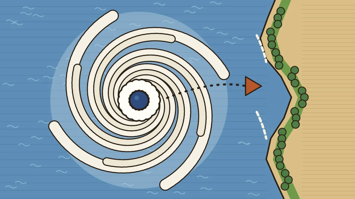
| Part | What it is like |
|---|---|
| Eye | The centre. A region of calm, clear weather with subsiding (sinking) air and the lowest pressure. Wrongly assumed by many to be the storm's front |
| Eyewall | The ring around the eye where air rises steeply to the tropopause. Winds are strongest here (up to about 250 km/h in the NCERT account) and rain is torrential |
| Rain bands | Spiral arms of cumulus and cumulonimbus clouds radiating outwards from the eyewall, bringing squalls and showers well ahead of the centre |
Over the Bay of Bengal and the Arabian Sea a mature storm is 600–1,200 km across and extends up to 12–14 km in height. When the eye passes over a place the storm seems to stop, and then the wind returns from the opposite direction. In the Northern Hemisphere the side of the storm to the right of its track is the more dangerous, because the storm's forward motion adds to its wind speed there.
The cyclone's centre is a low-pressure area. An anticyclone has high pressure at the centre and brings fair weather. The "eye" is the calm centre, not the "front side" of the cyclone. Both wrong statements appeared in CDS 2019-I (see the past papers below).
Why the Bay of Bengal, and Why Two Seasons
The North Indian Ocean makes up only a small share of the world's tropical cyclones, but it is among the deadliest. Within it, the Bay of Bengal produces several times as many storms as the Arabian Sea. The reasons:
- Warm and nearly land-locked. The Bay's sea-surface temperature stays around 29–30 °C through the year, and it is enclosed on three sides, so no cold water flows in.
- More moisture. Dry air from the Arabian peninsula and the stronger winds over the Arabian Sea keep that sea cooler and drier.
- Ready-made disturbances. Low-pressure systems form over the Bay and the Andaman Sea.
| Season | Months | Character |
|---|---|---|
| Pre-monsoon | April–June (peak in May) | Fewer storms. Fani (2019) and Amphan (2020) came now |
| South-west monsoon | June–September | Strong wind shear holds full cyclones back. Monsoon depressions form instead, near the head of the Bay |
| Post-monsoon | October–December (peak in November) | The most dangerous season: warm sea, falling wind shear, and a coastline still wet from the monsoon |
After the monsoon withdraws in October, the upper-air shear eases while the sea is still hot from the summer, and the cyclone engine runs well. These storms move north-west or west and strike Tamil Nadu, Andhra Pradesh, Odisha and West Bengal, and sometimes Bangladesh and Myanmar. The thickly populated deltas of the Godavari, Krishna and Kaveri are favourite targets. The same storms feed the north-east monsoon rain of the Coromandel coast, which receives much of its annual total from these depressions and cyclones. That is why October and November are the rainiest months of the eastern Peninsula, a point we cover in our article on the Indian monsoon mechanism. The funnel-shaped head of the Bay and the shallow shelf off Odisha, West Bengal and Bangladesh also pile up the water, making the surge worse than on the Arabian Sea coast.
IMD's Wind Ladder and the Naming System
The India Meteorological Department (IMD) ranks a system by its maximum sustained surface wind averaged over three minutes.
| Category | Wind (km/h) | Named? |
|---|---|---|
| Depression | 31–49 | No |
| Deep depression | 50–61 | No |
| Cyclonic storm | 62–88 | Name given here (34 knots) |
| Severe cyclonic storm | 89–117 | Yes |
| Very severe cyclonic storm | 118–166 | Yes |
| Extremely severe cyclonic storm | 167–221 | Yes |
| Super cyclonic storm | 222 and above | Yes |
The names come from a list run by the WMO/ESCAP Panel on Tropical Cyclones, with IMD's RSMC New Delhi allotting each name in turn. Naming began in 2004 with eight countries (Bangladesh, India, Maldives, Myanmar, Oman, Pakistan, Sri Lanka and Thailand). In 2018 the panel grew to 13 members with Iran, Qatar, Saudi Arabia, the UAE and Yemen. After Amphan used up the old list in 2020, a new list of 169 names, 13 from each member, took over. Names run column by column in the alphabetical order of the contributing countries, are never reused, and must be short and free of political, religious or gender sensitivity.
| Storm | Year | Name given by |
|---|---|---|
| Phailin (Odisha) | 2013 | Thailand (old list) |
| Fani (Odisha) | 2019 | Bangladesh (old list) |
| Amphan (West Bengal) | 2020 | Thailand (last name on the old list) |
| Nisarga (Maharashtra) | 2020 | Bangladesh (new list) |
| Gati, Nivar, Tauktae, Yaas | 2020–21 | India, Iran, Myanmar, Oman |
| Arnab (Andhra Pradesh, Yanam) | 2026 | Bangladesh; next is Murasu (India) |
Our two articles on Arnab, one on how Bay of Bengal storms are named and ranked and the other on why storms weaken after landfall and how India responds, follow this year's case in detail.
Storm Surge and Four Storms to Remember
A storm surge is the abnormal rise of sea level along the coast as a cyclone comes ashore. Very strong onshore winds push water against the coast, and the low pressure at the centre lets the sea bulge up. If the surge arrives at high tide, the sea can flood many kilometres inland. Storm surge, not wind, has caused most cyclone deaths on this coast. Coastal mangroves act as natural buffers against both surge and wind, which is why India launched the MISHTI mangrove scheme in 2023.
| Cyclone | Landfall | Facts to remember |
|---|---|---|
| 1999 Odisha (the "Super Cyclone") | 29 October 1999, near Paradip | A super cyclonic storm with winds of about 260 km/h and a record low pressure of 912 hPa for the North Indian Ocean. Surge of 5–6 m reached about 35 km inland. About 9,900 deaths officially |
| Phailin | 12 October 2013, near Gopalpur, Odisha | Peak winds about 215 km/h. About one million people were moved to shelters, and deaths were fewer than 50 |
| Fani | 3 May 2019, near Puri, Odisha | An extremely severe storm of about 185 km/h at landfall. Among the strongest storms to hit Odisha since 1999. Over 1.2 million moved in Odisha |
| Amphan | 20 May 2020, near Bakkhali, West Bengal | A super cyclonic storm at peak (about 240 km/h), the strongest in the Bay since 1999. About 155 km/h at landfall. Hit West Bengal and Bangladesh |
Phailin was as powerful as the 1999 storm at its peak, yet the death toll fell from thousands to dozens. The difference was early warning, mass evacuation and cyclone shelters. After 1999, Odisha built a state disaster authority and a network of shelters. Cyclones, unlike earthquakes, can be tracked, so the damage can be cut.
One Storm, Many Names
The same kind of storm has different names in different oceans. Note the basin, not the spelling.
| Name | Where |
|---|---|
| Cyclone | Indian Ocean (and South Pacific) |
| Hurricane | Atlantic and eastern North Pacific (USA) |
| Typhoon | Western Pacific and the South China Sea (China, Japan) |
| Baguio | The Philippines |
| Willy-willy | North-western Australia |
Do not confuse these with temperate (extra-tropical) cyclones. Temperate cyclones form along the polar front in middle and high latitudes, have clear warm and cold fronts, are larger, can form over land or sea and move west to east with the westerlies. Tropical cyclones have no fronts, form only over warm seas, move east to west with the trade winds, and have much stronger winds.
How UPSC Has Asked It: Past Papers Solved
These are real CDS and NDA questions.
Which one of the following may be the true characteristic of cyclones?
(a) Temperate cyclones move from west to east with westerlies whereas tropical cyclones follow trade winds. (b) The front side of cyclone is known as the 'eye of cyclone'. (c) Cyclones possess a centre of high pressure surrounded by closed isobars. (d) Hurricanes are well-known tropical cyclones which develop over mid-latitudes.
Answer: (a). The eye is the calm centre, a cyclone has low pressure at its middle, and hurricanes form over warm tropical seas, so (b), (c) and (d) are wrong.
Match List I with List II. List I: A. Cyclones, B. Hurricanes, C. Typhoons, D. Willy-willies. List II: 1. Western Australia, 2. South China Sea, 3. Indian Ocean, 4. Atlantic Ocean.
(a) A-3, B-2, C-4, D-1 (b) A-3, B-4, C-2, D-1 (c) A-1, B-4, C-2, D-3 (d) A-1, B-2, C-4, D-3
Answer: (b). Cyclones: Indian Ocean (3). Hurricanes: Atlantic (4). Typhoons: South China Sea (2). Willy-willies: Western Australia (1).
Which of the following statements regarding tropical cyclones is/are correct? 1. These storms develop during the summer and autumn in every tropical ocean except the South Atlantic and eastern South Pacific Oceans. 2. Tropical cyclones that occur in the North Atlantic and eastern North Pacific Oceans are known as typhoons. 3. Tropical cyclones that occur in the Indian and South Pacific Oceans are called cyclones.
(a) 3 only (b) 1 and 2 only (c) 1 and 3 only (d) 1, 2 and 3
Answer: (c). Statements 1 and 3 are correct. Statement 2 is the trap: in the North Atlantic and eastern North Pacific they are hurricanes, and typhoons belong to the western Pacific.
Which of the following statements regarding cyclones and anti-cyclones is/are correct? 1. In the Northern Hemisphere, cyclones rotate counterclockwise and anticyclones rotate clockwise. 2. Cyclones are often associated with cloudy or rainy weather, whereas anticyclones are often associated with fair weather. 3. In the Southern Hemisphere, the cyclonic spiral will be clockwise because the Coriolis force acts to the left.
(a) 1 only (b) 1 and 2 only (c) 2 and 3 only (d) 1, 2 and 3
Answer: (d). All three hold. The Coriolis force turns moving air to the right in the north and to the left in the south, so the sense of rotation reverses across the equator.
Which one of the following countries had chosen the name 'Nisarga' for the cyclone which devastated the coastline of Maharashtra and Gujarat in June 2020?
(a) Maldives (b) Bangladesh (c) Thailand (d) Japan
Answer: (b). Nisarga is Bangladesh's name, from the new 2020 list. Thailand supplied Phailin and Amphan, a tempting wrong choice, while Japan is not on the panel.
South Arcot and Ramanathapuram receive over 50 percent of their annual rainfall from which one of the following?
(a) South-west monsoon (b) North-east monsoon (c) Bay of Bengal branch of summer monsoon (d) Western disturbances
Answer: (b). The Tamil Nadu coast is in the rain shadow of the summer monsoon and gets its rain in October–December, much of it from depressions and cyclones of the Bay.
Consider the following statements: 1. Mangroves are natural buffers against cyclones, storm surges and coastal erosion. 2. Recognising it, India implemented the Mangrove Initiative for Shoreline Habitats and Tangible Incomes (MISHTI).
(a) 1 only (b) 2 only (c) Both 1 and 2 (d) Neither 1 nor 2
Answer: (c). Both are correct. Mangroves break the force of waves and surge, and MISHTI, launched in 2023, promotes mangrove plantation along the coast.
Most questions test basin names, hemisphere rotation, who named the storm and the difference between tropical and temperate cyclones. Check each statement separately.
Practice MCQs (with answers)
- A tropical cyclone needs a sea-surface temperature of at least about
- 10 °C
- 18 °C
- 26.5 °C
- 40 °C
- Tropical cyclones almost never form within 5° of the equator because
- the sea is too cold
- the Coriolis force is too weak
- there are no clouds
- there is no moisture
- The calm region at the centre of a mature cyclone, with sinking air, is the
- eyewall
- rain band
- landfall
- eye
- The strongest winds and heaviest rain of a cyclone are found in the
- eyewall
- outer rain bands
- eye
- the point of landfall
- IMD gives a system a name when it first reaches the stage of a
- depression
- deep depression
- cyclonic storm
- super cyclonic storm
- On IMD's scale, a sustained wind of 200 km/h makes a storm
- an extremely severe cyclonic storm
- a severe cyclonic storm
- a very severe cyclonic storm
- a super cyclonic storm
- Most deaths in the 1999 Odisha super cyclone were caused by
- landslides
- hail
- drought
- storm surge
- Names for cyclones over the Bay of Bengal are allotted by
- the UN Security Council
- IMD's RSMC New Delhi, from a list agreed by 13 countries
- the Ministry of Home Affairs
- the State that is hit
1-c, 2-b, 3-d, 4-a, 5-c, 6-a, 7-d, 8-b. Q6: 167–221 km/h is "extremely severe"; "super" starts at 222 km/h. Q7: the sea flooded the low coast, so the surge caused most deaths.
Quick Revision
- Five conditions: warm sea (26.5–27 °C+), Coriolis (not within ~5° of the equator), low wind shear, pre-existing low, upper divergence. Energy = latent heat. Dies over land: no moisture.
- Eye: calm, sinking air. Eyewall: strongest wind, heaviest rain. Rain bands: spiral clouds. Anticlockwise in the north, clockwise in the south.
- Bay of Bengal makes more storms than the Arabian Sea. Seasons: pre-monsoon (Apr–Jun), post-monsoon (Oct–Dec, peak November).
- IMD: depression 31–49; deep depression 50–61; cyclonic storm 62–88 (named); severe 89–117; very severe 118–166; extremely severe 167–221; super 222+ km/h.
- Naming: 2004 (8 countries), 13 members from 2018, 169-name list in 2020; Nisarga = Bangladesh, Arnab = Bangladesh, next Murasu (India).
- 1999: super cyclone, about 260 km/h, 29 October, surge 5–6 m. Phailin 2013: fewer than 50 deaths. Fani 3 May 2019. Amphan 20 May 2020, super cyclonic at peak.
- Cyclone, hurricane, typhoon, willy-willy: Indian Ocean, Atlantic, W. Pacific, Australia.
Frequently asked questions
Why do cyclones form in the Bay of Bengal in October and November?
After the south-west monsoon withdraws, the upper-air wind shear eases while the sea is still very warm, and moist air and low-pressure disturbances are plentiful. These are the conditions a tropical cyclone needs, so October to December is the peak season, with November the most active month.
Why does the Bay of Bengal get more cyclones than the Arabian Sea?
The Bay is warm all year, is enclosed on three sides and has more moisture. The Arabian Sea is cooler and drier because of strong winds and dry air from the Arabian peninsula. As a result, the Bay produces several times as many storms.
What is the difference between the eye and the eyewall?
The eye is the calm centre of the cyclone, with clear skies and sinking air. The eyewall is the ring of towering clouds around it, where air rises steeply, winds are strongest and rainfall is heaviest.
How are Bay of Bengal cyclones named?
Names come from a list of 169 names, 13 contributed by each of the 13 member countries of the WMO/ESCAP Panel on Tropical Cyclones. IMD allots a name when a system reaches cyclonic-storm strength, using the list column by column in the alphabetical order of countries. Names are never reused.
What is a storm surge?
A storm surge is the abnormal rise of sea level along the coast as a cyclone makes landfall. Strong winds push water onshore and the low pressure lets the sea bulge up. It floods low coasts and has caused most cyclone deaths in India.
Related CDS / OTA Geography topics
Climate and natural hazards come up in almost every CDS GS paper
Cavalier's CDS/OTA batches teach physical geography with diagrams, maps and weekly PYQ-based tests.