On 17 and 18 November 2026 the Parvat Manthan Conclave met in Dehradun. Organised by the National Institute of Urban Affairs, it brought together representatives of 11 Himalayan states to discuss water security, disaster risk, carrying capacity and municipal finance in mountain cities, and PIB reported that ten initiatives and publications were launched. The setting is a small geography lesson. Dehradun lies in a dun, a broad valley between the Lesser Himalaya and the Shiwalik hills, and every problem the conclave named, from landslides to scarce water, follows from how these mountains are built. UPSC asks about the Himalaya almost every year: ranges and their order, passes, valleys, glaciers and regional names. In CDS 2025-I, CDS 2026-I and NDA 2024-II alone there were at least four direct questions on it.
How the Himalaya Rose
The Himalaya are young fold mountains. Where they now stand there was once the Tethys Sea, a long, shallow ocean between the northern landmass and the Indian plate. Rivers from both sides dumped sediments into it for millions of years. Then the Indian plate, drifting north, collided with the Eurasian plate about 40 to 50 million years ago. The sea floor and its thick sediments were squeezed, folded and lifted. The push has not stopped, which is why the range is still rising and why the region is one of India's most earthquake-prone belts, as our page on plate tectonics explains.
The squeeze did not happen in one go. It came in pulses, and each pulse added a new range on the southern side. That is why the oldest range is the northernmost, the youngest the southernmost, and why the three ranges are separated by great thrust faults, where one block was pushed up and over its southern neighbour.
| Fault | Where it runs |
|---|---|
| Main Central Thrust (MCT) | Between the Great Himalaya (Himadri) and the Lesser Himalaya |
| Main Boundary Thrust (MBT) | Between the Lesser Himalaya and the Shiwaliks |
| Himalayan Frontal Thrust (HFT) | At the foot of the Shiwaliks, where the mountains meet the Northern Plain |
The mountains form an arc about 2,400 km long, running west to east from the Indus gorge to the Brahmaputra gorge. The width is not even: about 400 km in Kashmir narrowing to about 150 km in Arunachal Pradesh. They are a wall that shapes climate, rivers and culture. They block cold Central Asian air in winter and force the monsoon to drop its rain on the southern slopes, as described in our article on the Indian monsoon.
Three Parallel Ranges, South to North
From south to north the Himalaya consist of three long, parallel ranges. Learn them as a ladder, from the plains upward.
| Feature | Shiwalik (Outer) | Himachal (Lesser or Middle) | Himadri (Great or Inner) |
|---|---|---|---|
| Position | Southernmost | Middle | Northernmost |
| Height | About 900 to 1,100 m | About 3,700 to 4,500 m | Average about 6,000 m; the loftiest peaks |
| Width | 10 to 50 km | About 50 km | Continuous from west to east |
| Rock | Loose gravel, sand and clay brought down by rivers; weak and easily eroded | Highly compressed and altered (metamorphic) rocks | Granite core, with metamorphic rock around it |
| Age | Youngest | Middle | Oldest |
| Known for | Duns, foothill forests | Hill stations, the Kashmir, Kullu and Kangra valleys | Everest, Kanchenjunga, snow, glaciers |
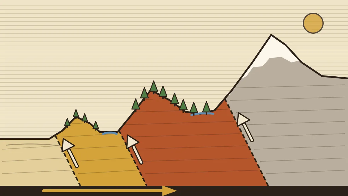
The Himadri. This is the only range that runs continuously from west to east and it holds almost every famous peak. Mount Everest (8,848 m) is on the Nepal-China border; Kanchenjunga (about 8,586 m, on the Sikkim-Nepal border) is the highest peak in India; Nanda Devi (about 7,800 m, Uttarakhand) is the highest peak lying wholly inside India. Many glaciers descend from the range, including Gangotri and Yamunotri. They feed the northern rivers and keep them perennial. Because the folds here are asymmetrical, the southern face is steep and the northern face gentler.
The Himachal. This is the most rugged belt. It includes the Pir Panjal (the longest and most important range of this belt), the Dhauladhar and the Mahabharat. Most hill stations lie here: Shimla, Mussoorie, Nainital, Ranikhet, Almora and Darjeeling. South-facing slopes are steep and often bare, while the gentler north-facing slopes carry dense forest. Vegetation changes with height, from foothill sal to oak, rhododendron and alpine meadows, as covered on our page on India's natural vegetation.
The Shiwalik. The rivers of the higher ranges carried gravel and mud into the shrinking Tethys, and later movements folded those fresh sediments into low hills. The material is loose, so the Shiwaliks are fragile, easily eroded and a major source of the silt in the plains. Between the Shiwaliks and the Lesser Himalaya lie long, flat valleys called duns: Dehradun, Kotli Dun and Patli Dun are the standard examples. At the foot of the Shiwaliks the plain begins with the bhabar, a belt of boulders where streams sink, followed by the marshy terai where they re-emerge.
A common slip is to put the Shiwaliks in the north because they are "outer". Outer means outer towards the plains, so it is the southernmost. The height ladder, from the plain: Shiwalik (about 1,000 m), Himachal (3,700-4,500 m), Himadri (above 6,000 m).
North of the Great Himalaya: Zaskar, Ladakh, Karakoram
Beyond the Himadri, in Jammu and Kashmir and Ladakh, lie more ranges. Together they are called the Trans-Himalaya, though many writers treat the Zaskar and Ladakh ranges as part of the Kashmir Himalaya. Going north from the Great Himalaya the order is Zaskar, Ladakh, Karakoram, Kunlun, and the Indus flows north-west between the Zaskar and Ladakh ranges. This is the order CDS 2025-I asked (worked out below).
- Karakoram. Called Krishnagiri in Sanskrit literature. It holds K2 (8,611 m), the second-highest peak in the world and the highest of the Karakoram, and giant glaciers such as the Siachen in the Nubra valley region.
- Ladakh plateau. A very high, cold and dry region in the rain shadow of the Himalaya, with little vegetation and a thin population.
- Kashmir valley. An oval basin between the Pir Panjal in the south-west and the Great Himalaya (Himadri) in the north-east. The Jhelum meanders across its floor. Its famous karewas are thick deposits of clay, sand and gravel left by an ancient lake, with glacial material and moraines. They are well suited to saffron, almond and walnut orchards.
The rivers also matter here. The Indus, Sutlej and Brahmaputra are antecedent rivers: they existed before the Himalaya rose and kept cutting down as the land lifted, forming deep gorges through the Great Himalaya. Our page on the Himalayan river systems covers them in full.
West to East: The River-Valley Divisions
The ranges run east-west, so there is a second way to cut the mountains: into regions, marked by river valleys.
| Region | Between | Local names and notes |
|---|---|---|
| Punjab Himalaya | Indus and Sutlej | Known as the Kashmir Himalaya in the west and the Himachal Himalaya in the east |
| Kumaon Himalaya | Sutlej and Kali | Uttarakhand: Nanda Devi, Kamet, Gangotri |
| Nepal Himalaya | Kali and Teesta | Highest part: Everest, Kanchenjunga, Annapurna, Dhaulagiri |
| Assam Himalaya | Teesta and Dihang | Bhutan, Arunachal Pradesh; the Dihang is the Brahmaputra where it enters India |
Beyond the Dihang gorge the mountains bend sharply south and become the Purvanchal, the Eastern Hills along India's border with Myanmar. They are mainly strong sandstones that run as parallel ranges and valleys under dense forest: the Patkai hills, the Naga hills, the Manipur hills and the Mizo hills, with the Mishmi hills at the northern end. The Meghalaya plateau (Garo, Khasi and Jaintia hills) is in the same corner but is structurally a detached piece of the Peninsular plateau.
The eastern Himalaya rise abruptly from the plains of Bengal and Assam, so Everest and Kanchenjunga are comparatively close to the plain. In the west they rise gradually, with several ranges in between. That is why Nanda Devi and Badrinath stand far from the plain.
Passes: Which Range, Which Valley
A pass is a gap that lets people, trade and armies cross a range, and it is one of the most reliable question types.
| Pass | Range or area | Connects |
|---|---|---|
| Zoji La | Great Himalaya (as the NDA 2024-II key treats it) | Srinagar and Kargil-Leh |
| Banihal | Pir Panjal | Jammu and the Kashmir valley (the Jawahar tunnel runs beneath) |
| Rohtang La | Pir Panjal | Kullu valley and Lahaul-Spiti (the Atal tunnel runs beneath) |
| Baralacha La, Photu La | Zaskar range | Himachal to Ladakh; Photu La lies on the Srinagar-Leh road |
| Khardung La, Chang La | Ladakh range | Leh to the Nubra valley; Leh to Pangong |
| Lanak La | Aksai Chin | Ladakh with Tibet, on the old route to Lhasa |
| Shipki La | Sutlej valley | Himachal (Kinnaur) with Tibet; the Sutlej enters India here |
| Lipulekh, Niti, Mana | Kumaon-Garhwal | Uttarakhand with Tibet; Lipulekh is on the Kailash Mansarovar route |
| Nathu La, Jelep La | Sikkim | Sikkim with Tibet's Chumbi valley |
Outside the Indian Himalaya sit passes the examiner uses as distractors: Bolan and Khyber (Pakistan, to the west), Burzil and Babusar (toward Gilgit). Modern tunnels now beat the passes: the Zojila tunnel breakthrough of June 2026 is meant to end the six-month winter cut-off between the Kashmir valley and Ladakh.
Why This Matters: Building Cities on a Young Mountain
The geology above explains the four sessions of the Parvat Manthan Conclave. Weak Shiwalik sediments and steep, shattered Lesser Himalaya slopes make landslides and flash floods common, which is the subject of our articles on Himalayan cloudbursts and glacial lake outburst floods. The conclave asked for disaster-risk assessments inside city planning, water management that goes beyond municipal boundaries (springs and watersheds do not stop at a city limit), carrying-capacity assessments in statutory master plans, and predictable funds and hill-specific costing for municipal finance. It also recognised 18 urban solutions under Urban Learnathon 2.0. For an officer, the lesson is that a project that is routine on the plain, such as a road or a multi-storey block, is a different engineering and ecological problem on a slope.
How UPSC Has Asked It: Past Papers Solved
These are real CDS and NDA questions. They test the north-south order, the pass-range pairs and the north-west Himalaya.
What is the correct sequence of the following mountain ranges as one moves from North towards South? 1. Karakoram 2. Kunlun 3. Ladakh 4. Zaskar
(a) 1, 2, 3, 4 (b) 1, 2, 4, 3 (c) 2, 1, 4, 3 (d) 2, 1, 3, 4
Answer: (d). Kunlun is the northernmost, then Karakoram, then Ladakh, then Zaskar. Option (c) swaps the last two, the usual mistake.
Which one of the following passes is not located in Indian Himalayan region?
(a) Zojila (b) Bolan (c) Shipkila (d) Lipulekh
Answer: (b). Bolan lies in Balochistan, Pakistan. Zojila is in Ladakh, Shipki La in Himachal and Lipulekh in Uttarakhand.
Which of the following pairs of Himalayan Passes and the Ranges in which they are located is/are correctly matched? 1. Zoji La – Great Himalayas 2. Banihal Pass – Pir Panjal Range 3. Photu La – Ladakh Range 4. Khardung La – Karakoram Range
(a) 2 only (b) 4 (c) 1 and 2 only (d) 1, 2 and 3
Answer: (c). Pairs 1 and 2 are right. Photu La is in the Zaskar range, and Khardung La is in the Ladakh range, so pairs 3 and 4 are wrong.
Consider the following statements regarding the Northwestern Himalayas: 1. Karewa formations in Kashmir consist of thick deposits of glacial clay and other materials embedded with moraines. 2. Pangong Tso and Tso Moriri in Ladakh are freshwater lakes. 3. River Jhelum exhibits meanders in the Kashmir Valley.
(a) 1 only (b) 1 and 3 only (c) 2 and 3 only (d) 1, 2 and 3
Answer: (b). Statements 1 and 3 are correct. Statement 2 is the trap: Pangong Tso is a brackish-to-saline lake, not a freshwater one.
'Shipki La', a high altitude pass in the Himalayas, is located in:
(a) Chumbi Valley (b) Brahmaputra Valley (c) Satluj Valley (d) Teesta Valley
Answer: (c). Shipki La is where the Sutlej enters India from Tibet. Chumbi Valley is the tempting wrong option: it holds Nathu La and Jelep La in Sikkim.
Brahmaputra and Indus rivers are antecedent rivers. Which one of the following may be the true definition of an antecedent drainage?
(a) Which follows the initial slope of the Himalaya (b) Which existed before the Himalayan range came into existence (c) Which followed the dip or rock beds of the Himalaya (d) Which followed the strikes of rock beds of the Himalaya
Answer: (b). Antecedent rivers are older than the mountain and cut gorges as it rose. Option (a) describes a consequent river, which flows down the original slope.
Himalaya questions ask for one fact along a line: which range comes first going north, which range holds a pass, which valley a pass overlooks. Draw the section in your head (plain, Shiwalik, dun, Himachal, Himadri, Zaskar, Ladakh, Karakoram, Kunlun) and place each pass on it.
Practice MCQs (with answers)
- The longitudinal valleys between the Lesser Himalaya and the Shiwaliks are called
- duars
- terai
- karewas
- duns
- Which one of the following is the highest peak lying wholly within India?
- Nanda Devi
- Mount Everest
- Annapurna
- Dhaulagiri
- The Himalayan Frontal Thrust lies between
- the Himadri and the Himachal
- the Himachal and the Shiwaliks
- the Shiwaliks and the Northern Plain
- the Zaskar and the Ladakh ranges
- Which of the following is correctly matched?
- Rohtang La: Sikkim
- Nathu La: Himachal Pradesh
- Banihal: Pir Panjal
- Lipulekh: Ladakh
- The part of the Himalaya between the Sutlej and the Kali rivers is the
- Punjab Himalaya
- Kumaon Himalaya
- Nepal Himalaya
- Assam Himalaya
- Karewas of the Kashmir valley are best known for
- saffron and almond orchards
- tea plantations
- coffee estates
- cotton fields
- Which range is the northernmost of the following?
- Pir Panjal
- Karakoram
- Ladakh
- Shiwalik
- The Himalayas bend sharply south beyond which gorge to form the Purvanchal?
- The Indus
- The Teesta
- The Sutlej
- The Dihang
1-d, 2-a, 3-c, 4-c, 5-b, 6-a, 7-b, 8-d. Q1: duars are the foothill plains of Bengal and Assam, and the terai is the marshy belt farther south. Q2: Kanchenjunga is on the Sikkim-Nepal border, and the other three lie in Nepal. Q3: the MCT is option (a) and the MBT is option (b). Q4: Rohtang La is in Himachal, Nathu La in Sikkim, and Lipulekh in Uttarakhand. Q5: the Punjab Himalaya lie between the Indus and the Sutlej. Q7: the Pir Panjal and Shiwalik lie south of the Great Himalaya; the Karakoram is north of the Ladakh range. Q8: the Dihang is the Brahmaputra's name where it enters India.
Quick Revision
- Young fold mountains from the Tethys Sea sediments; Indian plate hit Eurasia about 40-50 million years ago; still rising, seismically active.
- Arc about 2,400 km; width 400 km (Kashmir) to 150 km (Arunachal). Faults: MCT (Himadri-Himachal), MBT (Himachal-Shiwalik), HFT (Shiwalik-plain).
- South to north: Shiwalik (900-1,100 m, loose sediments, duns) → Himachal (3,700-4,500 m; Pir Panjal, Dhauladhar, Mahabharat; hill stations) → Himadri (avg 6,000 m; granite core; Everest, Kanchenjunga, Nanda Devi).
- Duns: Dehradun, Kotli, Patli. Bhabar (boulders) then terai (marsh) at the foot.
- Beyond Himadri: Zaskar → Ladakh → Karakoram (K2, Siachen) → Kunlun. Indus between Zaskar and Ladakh. Kashmir valley between Pir Panjal and Himadri; karewas, Jhelum.
- Regions: Punjab (Indus-Sutlej), Kumaon (Sutlej-Kali), Nepal (Kali-Teesta), Assam (Teesta-Dihang). Beyond the Dihang: Purvanchal (Patkai, Naga, Manipur, Mizo).
- Passes: Zoji La (Great Himalaya), Banihal and Rohtang (Pir Panjal), Baralacha and Photu (Zaskar), Khardung and Chang (Ladakh), Shipki La (Sutlej), Lipulekh/Niti/Mana (Uttarakhand), Nathu La/Jelep La (Sikkim). Bolan and Khyber are in Pakistan.
- Antecedent rivers: Indus, Sutlej, Brahmaputra. Parvat Manthan 2026: Dehradun, 17-18 Nov, 11 Himalayan states.
Frequently asked questions
Which are the three parallel ranges of the Himalaya?
From north to south they are the Himadri (Great Himalaya), the Himachal (Lesser or Middle Himalaya) and the Shiwalik (Outer Himalaya). The Himadri is the highest and holds Mount Everest and Kanchenjunga. The Shiwalik is the lowest, youngest and southernmost range, made of loose sediments.
What is a dun?
A dun is a broad longitudinal valley between the Lesser Himalaya and the Shiwalik hills, often covered by thick gravel and alluvium. Dehradun, Kotli Dun and Patli Dun are the standard examples. Uttarakhand's capital, Dehradun, lies in one.
Which is the highest peak in India?
Kanchenjunga, about 8,586 m on the Sikkim-Nepal border, is the highest peak in India. Nanda Devi, about 7,800 m in Uttarakhand, is the highest peak that lies wholly inside India. Mount Everest is in Nepal, and K2 is in the Karakoram.
What are the regional divisions of the Himalaya from west to east?
They are named after the river valleys that mark them: the Punjab Himalaya between the Indus and the Sutlej, the Kumaon Himalaya between the Sutlej and the Kali, the Nepal Himalaya between the Kali and the Teesta, and the Assam Himalaya between the Teesta and the Dihang. Beyond the Dihang gorge lie the Purvanchal hills.
What is an antecedent river?
An antecedent river is one that existed before the mountain rose and kept its course by cutting down through the land as it was lifted. The Indus, the Sutlej and the Brahmaputra are the standard examples, and they flow through deep gorges in the Himalaya.
Related CDS / OTA Geography topics
Himalaya questions are map questions in disguise
Cavalier's CDS/OTA and NDA batches teach geography with outline maps, range-by-range drills and weekly PYQ tests.